Where is Cherokee?
DO NOT USE GPS, MAPQUEST, ETC. FOR DIRECTIONS. PLEASE USE DIRECTIONS FOUND BELOW.
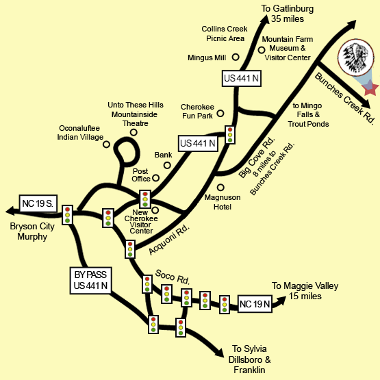
Driving Directions
From Atlanta:
GPS to Cherokee. Exit 74 off of 74 keeps you on 441. When you come into Cherokee, continue on 441 (left at the top of the hill, pass the Phoenix Movie Theater, then left at the bottom of a hill) all the way into town and past the gift shops. You will pass Peter's Pancakes on your right. 1/2 mile later, turn right onto Acquoni Rd. Then turn left at the Firehouse Subs onto Big Cove Rd. Take Big Cove Rd. for approx. 8.5 miles. Follow the Indian Creek Campground signs. Turn right onto Bunches Creek Rd. Continue on Bunches Creek Rd. for 1-1/2 miles.
From Asheville:
Take 40 West to exit 27 onto Rte 74, then:
Avoid getting off Rte 74 and going US 19 trough Maggie Valley.
GPS to Cherokee. Exit 74 off of 74 keeps you on 441. When you come into Cherokee, continue on 441 (left at the top of the hill, pass the Phoenix Movie Theater, then left at the bottom of a hill) all the way into town and past the gift shops. You will pass Peter's Pancakes on your right. 1/2 mile later, turn right onto Acquoni Rd. Then turn left at the Firehouse Subs onto Big Cove Rd. Take Big Cove Rd. for approx. 8.5 miles. Follow the Indian Creek Campground signs. Turn right onto Bunches Creek Rd. Continue on Bunches Creek Rd. for 1-1/2 miles.
From Pigeon Forge/Gatlinburg and north:
If you are towing, be advised this route takes you over the Smoky mountains through Newfound Gap. This is a steep curvy road. If you feel this is not safe or outside of your tow vehicles safety range, take I40 east into NC and follow the directions used from Asheville.
Once you decide to take this route,
It is advised when coming thru Gatlinburg area, use the Gatlinburg bypass to avoid heavy downtown traffic.
Take 441 South through the National Park. At the 1st traffic light, turn left. Then turn immediately left again onto Big Cove Rd. Take Big Cove Rd. for approx. 8.5 miles. Follow the Indian Creek Campground signs. Turn right onto Bunches Creek Rd. Continue on Bunches Creek Rd. for 1-1/2 miles.
Cherokee, North Carolina is located in the most western region of North Carolina
- 33 miles south of Gatlinburg, Tennessee
- 65 miles west of Asheville, North Carolina
Here are some of the most common driving distances (in miles):
| Asheville, NC | 65 | Indianapolis, IN | 478 |
| Atlanta, GA | 150 | Jacksonville, FL | 485 |
| Bryson City, NC | 10 | Knoxville, TN | 70 |
| Charleston, SC | 316 | Louisville, KY | 360 |
| Charlotte, NC | 162 | Murphy, NC | 50 |
| Cincinnati, OH | 363 | New Orleans, LA | 638 |
| Franklin, NC | 30 | Tampa, FL | 682 |
| Gatlinburg, TN | 33 | Washington, DC | 560 |